Birding at 1800
Earlier in the day Jean and I had spent 4 hours birding the Creston Valley Wildlife Management Area, adding 5 species to our life list. The day before we had discussed which spot on the Selkirk Loop we should visit after the WMA.
Boundary Creek WMA near Porthill, Idaho was a possibility. Adding an additional state list to my e-Bird data would be great and we had passports, so our entry into the United States would be less problematic. The other choice was Stagleap Provincial Park on the Crowsnest Highway, west of Creston.
Ascending the Crowsnest Highway east of the summit was a gradual climb. In fact, I was oblivious during our ascent until I noticed the car was no longer travelling at the posted 100 km/hr. Looking to my left and seeing sheer, rocky mountains finally brought me to the realization we would soon be at the summit. Reaching the summit, we stopped briefly, looking for an entrance to Stagleap P.P. Was it on the descent of the west side of the summit? There was a small sign at the summit but to us it appeared there was no official notification of a provincial park. Noticing the car was low on gas we continued along the highway, reaching Salmo to refuel.

We would return to the Kootenay Pass from the west. Here are some views we observed during the climb.

Image by Bob
Elevation 1341 metres


Elevation 1561 metres
Returning to the summit of the highest all weather road in British Columbia, an elevation of 1774 metres, we parked the car in front of Bridal Lake (formerly Summit Lake). Upon completion of the highway the lake was renamed in celebration of the marriage of the east and west in the Kootenays. Across the highway were a couple of buildings and in-between them, a moose!

A quick photo request at the lake (thanks to a fellow traveller) and it was time to hike the trail to a viewpoint 100+ metres above the lake.

Starting our hike, Jean and I could see that no one had set foot on the trail recently. Well at least humans. In the mud we found the tracks of our four legged friend seen at the road side moments ago.
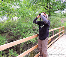
Jean birding at 1785 metres. Honestly. I did not set this up. The fallen tree is aligned perfectly to make the binoculars appear scope-like.

Image by Bob
We continued our ascent to the viewpoint coming across a few blooming Avalanche Lilies. I was so relieved they are named for their appearances after avalanches rather than as a cause of them.


I was certainly glad we encountered more snow (more snow=no ticks) at 1871 metres. So much snow, we missed the trail to the Cornice Ridge. Technically it's still Spring so N8 should not freak out too much.

Passing through the trees we stopped to find the Red-breasted Nuthatches that were calling. We observed the pair (adding the bird to the B.C. list) and continued along the mountain edge with open views of the valley to the north. While walking through another stand of conifers a Hermit Thrush was singing at the top of one of the trees. As we viewed the bird through our binoculars, a very different bird flew in claiming the tree top from the singing thrush. The moment I saw this bird I knew its identity and it was a lifer. A large finch-like bird with stubby black bill; rose-red head, chest and back; black wings with two white wing bars. A male Pine Grosbeak (#278).

The viewpoint was was not too far away but was not easy to access (more snow covering the trail). Searching for a way to climb a rock formation we found an opening in the trees to the east and observed the Crowsnest Highway down below (the grey line in the centre of the image).

Climbing up the sloping rock formation, we reached a cairn on the viewpoint, an elevation of 1880 metres.

Image by Bob
From the summit we could view Bridal Lake and our tiny car.

Returning along the way we came, no new birds were encountered nor any other hikers. Birding in the peacefulness and cool fresh air of the Kootenays was fulfilling indeed.


We descended Highway 3 into the Creston Valley, hungry from our day of birding. Jean's mum had told us that there was a Mexican restaurant in Creston but could not remember the name. Highway 3 runs through the downtown but no names indicated Mexican other than La Hacienda (a hotel). Some quick inquiries at a 7-11 led us to the Break in Time (not the restaurant Jean's mum had dined at in the past). Many thanks to the customer in the 7-11! The food was Mexican and excellent!! If you ever find yourself birding this section of the Selkirk Loop, I highly recommend stopping at this restaurant.

June 18th was a great day of birding. We had birded the Creston Valley and the sub-alpine forest of Stagleap Provincial Park at the Kootenay Pass, ticking a total of 6 lifers. There was still a few days left of our vacation in the west, enough time to find the species that still remained on our target list.
All images by Jean unless otherwise stated.


No comments:
Post a Comment